GDCI’s How to Evaluate Street Transformations guide contains basic, ready-to-print checklists, forms, and community engagement boards to support your data collection. You can digitally add basemaps of your site where needed or simply hand-draw it once it has been printed. Refer back to Section B3 for examples of what the forms might look like when completed.
If you prefer to work with digital resources, or customize the forms provided, click the ‘Excel Download’ button above. On this spreadsheet you will find:
One tab for each of the provided forms
A reference library of street users and the corresponding icons that you can copy and paste into your new forms. These are just suggestions, you can also create your own.
Sample data processing tables for pedestrian counts and vehicular speeds, like the ones shown on pages 64 to 67.
These tools are also available in the following languages:
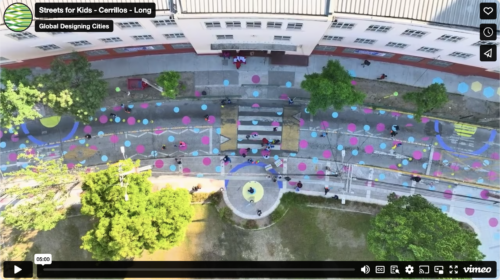
Buzeta ‘Caminable’ – Opening Streets for Play and Physical Activity in Cerrillos, Chile
Ciudad Emergente partnered with the Municipality of Cerrillos and the Mayor University to do a pop-up transformation of 7th Avenue into a pedestrian-friendly space, connecting an elementary school serving 350 children with a nearby park, and creating a safer and more playful space.
The Municipality of León, Mexico, partnered with the Governmental Family Services Agency (DIF) and the non-profit Colectivo Tomate to pilot an interim street transformation creating a safe, accessible, and playful path to key destinations serving nearly 1,000 children daily.
Surakarta Child-friendly and Inclusive City (SUKARIA)
In Solo, Indonesia, the non-profit Kota Kita partnered with the Surakarta City Department of Transportation to redesign two streets near a high school, benefiting more than 500 students and residents. More than 400 kids, caregivers, and community members participated. The interim transformation created a safer, more attractive, and more inclusive environment for children by reclaiming public space for pedestrians and introducing traffic-calming elements and street art.