-
About Streets
- Introduction
- Defining Streets
-
Shaping Streets
- The Process of Shaping Streets
- Aligning with City and Regional Agendas
- Involving the Right Stakeholders
- Setting a Project Vision
- Communication and Engagement
- Costs and Budgets
- Phasing and Interim Strategies
- Coordination and Project Management
- Implementation and Materials
- Management
- Maintenance
- Institutionalizing Change
- Measuring and Evaluating Streets
-
Street Design Guidance
- Designing Streets for Great Cities
- Designing Streets for Place
-
Designing Streets for People
- Utilities and Infrastructure
- Operational and Management Strategies
- Design Controls
-
Street Transformations
- Streets
-
Intersections
- Intersection Design Strategies
- Intersection Analysis
- Intersection Redesign
- Mini Roundabout
- Small Raised Intersection
- Neighborhood Gateway Intersection
- Intersection of Two-Way and One-Way Streets
- Major Intersection: Reclaiming the Corners
- Major Intersection: Squaring the Circle
- Major Intersection: Cycle Protection
- Complex Intersection: Adding Public Plazas
- Complex Intersection: Improving Traffic Circles
- Complex Intersection: Increasing Permeability
- Resources
Global Street Design Guide
-
About Streets
- Introduction
- Defining Streets
-
Shaping Streets
Back Shaping Streets
- The Process of Shaping Streets
- Aligning with City and Regional Agendas
- Involving the Right Stakeholders
- Setting a Project Vision
- Communication and Engagement
- Costs and Budgets
- Phasing and Interim Strategies
- Coordination and Project Management
- Implementation and Materials
- Management
- Maintenance
- Institutionalizing Change
-
Measuring and Evaluating Streets
Back Measuring and Evaluating Streets
-
Street Design Guidance
-
Designing Streets for Great Cities
Back Designing Streets for Great Cities
-
Designing Streets for Place
Back Designing Streets for Place
-
Designing Streets for People
Back Designing Streets for People
- Comparing Street Users
- A Variety of Street Users
-
Designing for Pedestrians
Back Designing for Pedestrians
- Designing for Cyclists
-
Designing for Transit Riders
Back Designing for Transit Riders
- Overview
- Transit Networks
- Transit Toolbox
-
Transit Facilities
Back Transit Facilities
-
Transit Stops
Back Transit Stops
-
Additional Guidance
Back Additional Guidance
-
Designing for Motorists
Back Designing for Motorists
-
Designing for Freight and Service Operators
Back Designing for Freight and Service Operators
-
Designing for People Doing Business
Back Designing for People Doing Business
-
Utilities and Infrastructure
Back Utilities and Infrastructure
- Utilities
-
Green Infrastructure and Stormwater Management
Back Green Infrastructure and Stormwater Management
-
Lighting and Technology
Back Lighting and Technology
-
Operational and Management Strategies
Back Operational and Management Strategies
- Design Controls
-
Street Transformations
-
Streets
Back Streets
- Street Design Strategies
- Street Typologies
-
Pedestrian-Priority Spaces
Back Pedestrian-Priority Spaces
-
Pedestrian-Only Streets
Back Pedestrian-Only Streets
-
Laneways and Alleys
Back Laneways and Alleys
- Parklets
-
Pedestrian Plazas
Back Pedestrian Plazas
-
Pedestrian-Only Streets
-
Shared Streets
Back Shared Streets
-
Commercial Shared Streets
Back Commercial Shared Streets
-
Residential Shared Streets
Back Residential Shared Streets
-
Commercial Shared Streets
-
Neighborhood Streets
Back Neighborhood Streets
-
Residential Streets
Back Residential Streets
-
Neighborhood Main Streets
Back Neighborhood Main Streets
-
Residential Streets
-
Avenues and Boulevards
Back Avenues and Boulevards
-
Central One-Way Streets
Back Central One-Way Streets
-
Central Two-Way Streets
Back Central Two-Way Streets
- Transit Streets
-
Large Streets with Transit
Back Large Streets with Transit
- Grand Streets
-
Central One-Way Streets
-
Special Conditions
Back Special Conditions
-
Elevated Structure Improvement
Back Elevated Structure Improvement
-
Elevated Structure Removal
Back Elevated Structure Removal
-
Streets to Streams
Back Streets to Streams
-
Temporary Street Closures
Back Temporary Street Closures
-
Post-Industrial Revitalization
Back Post-Industrial Revitalization
-
Waterfront and Parkside Streets
Back Waterfront and Parkside Streets
-
Historic Streets
Back Historic Streets
-
Elevated Structure Improvement
-
Streets in Informal Areas
Back Streets in Informal Areas
-
Intersections
Back Intersections
- Intersection Design Strategies
- Intersection Analysis
- Intersection Redesign
- Mini Roundabout
- Small Raised Intersection
- Neighborhood Gateway Intersection
- Intersection of Two-Way and One-Way Streets
- Major Intersection: Reclaiming the Corners
- Major Intersection: Squaring the Circle
- Major Intersection: Cycle Protection
- Complex Intersection: Adding Public Plazas
- Complex Intersection: Improving Traffic Circles
- Complex Intersection: Increasing Permeability
- Resources
- Guides & Publications
- Global Street Design Guide
- Designing Streets for People
- Designing for Motorists
- Motorist Networks
Motorist Networks
The primary goal of vehicle network design is to provide access to the city with personal motorized vehicles without disrupting other modes or urban life. Urban car trips include on-foot access at either end of the journey as well as time taken for parking. As with transit, the time spent in motion is a small portion of the total travel time. Motor vehicle travel times in urban areas are
more affected by intersection wait times and the availability of parking than by top operating speeds. Use pricing for parking and vehicle entry, as well as area-wide traffic metering, to discourage unnecessary vehicle use within the network. See: Operational and Management Strategies.
Classifying streets strictly into arterial, connector, and local is misleading because it considers only one user and can lead designers to neglect non-mobility functions and access for all users.
Some of the fundamental tasks related to urban vehicle network management are:
- Determining where and when access is to be provided, and for which vehicle types
- Creating basic network connectivity
- Preventing through traffic from overwhelming city streets
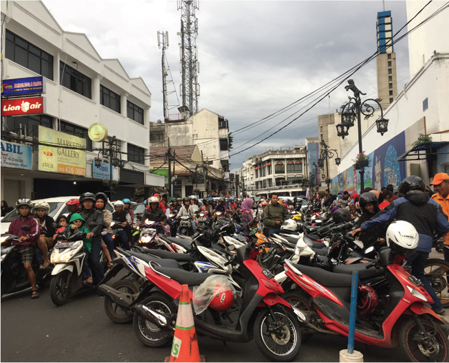
- Limiting the accumulation of automobiles in dense areas
For citywide access by personal motor vehicle, network connectivity is more important than the speed of each street segment. For automobiles, a street classification system should be based on the vehicle operating environment and the possibility of through movement, rather than the intended length of trips.
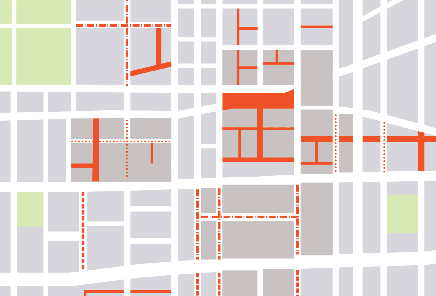
Grid systems provide connected networks, with frequent intersections allowing traffic management techniques and one-way operation with relatively short diversions. Parallel streets can serve different functions in a grid, and support distinct contexts. In some portions of the network, most streets may serve a through function, diminishing volume on each but spreading impacts around an area. In other areas, it may be advantageous for most streets to be filtered, raising vehicle volumes on the major street but providing a higher-quality environment on other streets.
A strategy of filtered permeability or area-wide metering can be used to prevent all streets from becoming through-streets. Through-moving vehicles can be encouraged to divert from a street at successive nodes, creating good access conditions for motor vehicles without permitting high vehicular volumes in sensitive portions of the street. Using street direction changes and diversions to discourage some through movement, and encouraging the use of less-sensitive routes through wayfinding and lane continuity can allow for the creation of successful neighborhood-scale shared street networks and slow zones.
At the citywide level, networks can be planned to permit surface connectivity between neighborhoods without entering the highest-density areas, discouraging the use of personal motorized vehicles for trips to concentrated destinations that are better served by transit.
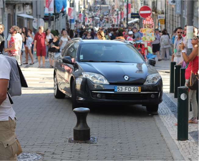
Car-free zones and delivery-only zones in city centers and other destination areas provide large public spaces and have a network-wide effect of reducing car traffic demand. This frees up capacity for freight and for trips that are less well-served by collective transit.
Slow Zones
Neighborhood Slow Zones are community- or city-led programs that reduce the speed limit to lower the risk of traffic crashes. Slow Zones enhance the quality of life for residents by making streets safer and reducing noise and air pollution. Local governments and communities should designate Slow Zones on local residential or neighborhood streets and areas around schools or key destinations. See: Traffic Calming Strategies.
Limited Traffic Zones
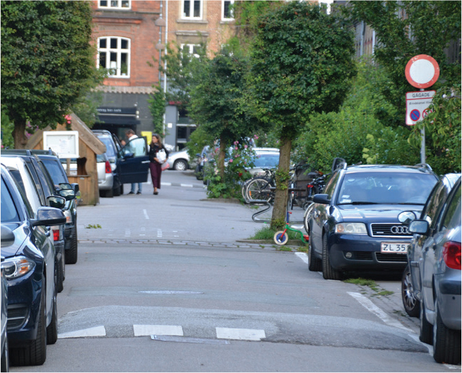
Limited traffic zones are areas where motorized traffic is restricted and access is allowed only for specific users or vehicles. This might include local residents, people with accessibility permits, environmentally friendly vehicles, loading vehicles, public utility vehicles, police and emergency vehicles, at specific hours, for loading purposes. Access to limited traffic zones may be completely restricted, permitted at certain hours, or permitted with an access fee. Traffic is generally physically restricted by using fixed or retractable bollards. See: Volume and Access Management.
Vehicle Networks: A variety of strategies, including car-free areas, shared spaces, slow zones, and limited traffic zones, is fundamental in order to allow access to the city with personal motorized vehicles without precluding the safety and the mobility of other modes.

Adapted by Global Street Design Guide published by Island Press.
Next Section —