-
About Streets
- Introduction
- Defining Streets
-
Shaping Streets
- The Process of Shaping Streets
- Aligning with City and Regional Agendas
- Involving the Right Stakeholders
- Setting a Project Vision
- Communication and Engagement
- Costs and Budgets
- Phasing and Interim Strategies
- Coordination and Project Management
- Implementation and Materials
- Management
- Maintenance
- Institutionalizing Change
- Measuring and Evaluating Streets
-
Street Design Guidance
- Designing Streets for Great Cities
- Designing Streets for Place
-
Designing Streets for People
- Utilities and Infrastructure
- Operational and Management Strategies
- Design Controls
-
Street Transformations
- Streets
-
Intersections
- Intersection Design Strategies
- Intersection Analysis
- Intersection Redesign
- Mini Roundabout
- Small Raised Intersection
- Neighborhood Gateway Intersection
- Intersection of Two-Way and One-Way Streets
- Major Intersection: Reclaiming the Corners
- Major Intersection: Squaring the Circle
- Major Intersection: Cycle Protection
- Complex Intersection: Adding Public Plazas
- Complex Intersection: Improving Traffic Circles
- Complex Intersection: Increasing Permeability
- Resources
Global Street Design Guide
-
About Streets
- Introduction
- Defining Streets
-
Shaping Streets
Back Shaping Streets
- The Process of Shaping Streets
- Aligning with City and Regional Agendas
- Involving the Right Stakeholders
- Setting a Project Vision
- Communication and Engagement
- Costs and Budgets
- Phasing and Interim Strategies
- Coordination and Project Management
- Implementation and Materials
- Management
- Maintenance
- Institutionalizing Change
-
Measuring and Evaluating Streets
Back Measuring and Evaluating Streets
-
Street Design Guidance
-
Designing Streets for Great Cities
Back Designing Streets for Great Cities
-
Designing Streets for Place
Back Designing Streets for Place
-
Designing Streets for People
Back Designing Streets for People
- Comparing Street Users
- A Variety of Street Users
-
Designing for Pedestrians
Back Designing for Pedestrians
- Designing for Cyclists
-
Designing for Transit Riders
Back Designing for Transit Riders
- Overview
- Transit Networks
- Transit Toolbox
-
Transit Facilities
Back Transit Facilities
-
Transit Stops
Back Transit Stops
-
Additional Guidance
Back Additional Guidance
-
Designing for Motorists
Back Designing for Motorists
-
Designing for Freight and Service Operators
Back Designing for Freight and Service Operators
-
Designing for People Doing Business
Back Designing for People Doing Business
-
Utilities and Infrastructure
Back Utilities and Infrastructure
- Utilities
-
Green Infrastructure and Stormwater Management
Back Green Infrastructure and Stormwater Management
-
Lighting and Technology
Back Lighting and Technology
-
Operational and Management Strategies
Back Operational and Management Strategies
- Design Controls
-
Street Transformations
-
Streets
Back Streets
- Street Design Strategies
- Street Typologies
-
Pedestrian-Priority Spaces
Back Pedestrian-Priority Spaces
-
Pedestrian-Only Streets
Back Pedestrian-Only Streets
-
Laneways and Alleys
Back Laneways and Alleys
- Parklets
-
Pedestrian Plazas
Back Pedestrian Plazas
-
Pedestrian-Only Streets
-
Shared Streets
Back Shared Streets
-
Commercial Shared Streets
Back Commercial Shared Streets
-
Residential Shared Streets
Back Residential Shared Streets
-
Commercial Shared Streets
-
Neighborhood Streets
Back Neighborhood Streets
-
Residential Streets
Back Residential Streets
-
Neighborhood Main Streets
Back Neighborhood Main Streets
-
Residential Streets
-
Avenues and Boulevards
Back Avenues and Boulevards
-
Central One-Way Streets
Back Central One-Way Streets
-
Central Two-Way Streets
Back Central Two-Way Streets
- Transit Streets
-
Large Streets with Transit
Back Large Streets with Transit
- Grand Streets
-
Central One-Way Streets
-
Special Conditions
Back Special Conditions
-
Elevated Structure Improvement
Back Elevated Structure Improvement
-
Elevated Structure Removal
Back Elevated Structure Removal
-
Streets to Streams
Back Streets to Streams
-
Temporary Street Closures
Back Temporary Street Closures
-
Post-Industrial Revitalization
Back Post-Industrial Revitalization
-
Waterfront and Parkside Streets
Back Waterfront and Parkside Streets
-
Historic Streets
Back Historic Streets
-
Elevated Structure Improvement
-
Streets in Informal Areas
Back Streets in Informal Areas
-
Intersections
Back Intersections
- Intersection Design Strategies
- Intersection Analysis
- Intersection Redesign
- Mini Roundabout
- Small Raised Intersection
- Neighborhood Gateway Intersection
- Intersection of Two-Way and One-Way Streets
- Major Intersection: Reclaiming the Corners
- Major Intersection: Squaring the Circle
- Major Intersection: Cycle Protection
- Complex Intersection: Adding Public Plazas
- Complex Intersection: Improving Traffic Circles
- Complex Intersection: Increasing Permeability
- Resources
- Guides & Publications
- Global Street Design Guide
- Streets
- Special Conditions
- Elevated Structure Removal
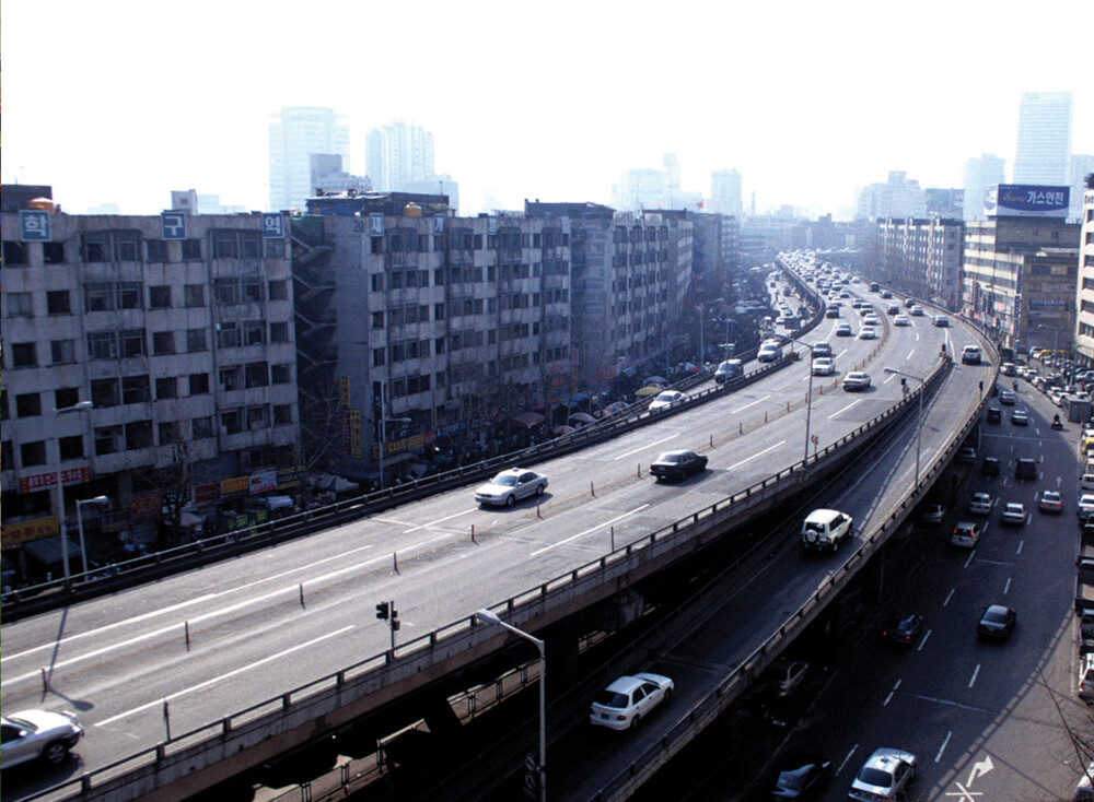
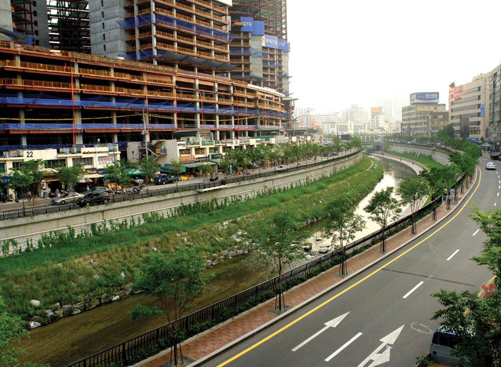
- Case Study: Cheonggyecheon; Seoul, Korea
Case Study: Cheonggyecheon; Seoul, Korea

Location: Jung Gu (Central District), Seoul, South Korea
Population: 10.1 million
Metro: 25.6 million
Extent: 5.8 km (Length) 292,000 m(Area)
Right-of-Way: 50 m
Context: Mixed-Use (Residential/Commercial)
Cost: 386,739 million KRW (345.2 million USD)
Funding: Seoul Metropolitan Government
Project Sponsors: Seoul Metropolitan Government
Overview
The Seoul Metropolitan Government decided to dismantle the 10-lane roadway and the 4-lane elevated highway that carried over 170,000 vehicles daily along the Cheonggyecheon stream. The transformed street encourages transit use over private car use, and more environmentally sustainable, pedestrian oriented public space. The project contributed to a 15.1% increase in bus ridership and a 3.3% increase in subway ridership between 2003 and 2008. The revitalized street now attracts 64,000 visitors daily.
Goals
- Improve air quality, water quality, and quality of life.
- Reconnect the two parts of the city that were previously divided by road infrastructure.
Lessons Learned
Innovative governance and interagency coordination were critical to the process.
Public engagement, with residents, local merchants, and entrepreneurs, was important to streamlining the process.
Reducing travel-lane capacity resulted in a decrease in vehicle traffic.
Involvement
Public Agencies
Central Government, Seoul Municipality, Seoul Metropolitan Government, Cultural Heritage Administration
Private Groups and Partnerships
Cheonggyecheon Research Group
Citizen Associations and Unions
Citizen’s Committee for Cheonggyecheon Restoration Project
Designers and Engineers
Seoul Development Institute urban design team, Dongmyung Eng, Daelim E&C
Close to 4,000 meetings were held with residents. A “Wall of Hope” program was developed to encourage involvement and resulted in 20,000 participants.
Evaluation

Key Elements
Removal of elevated highway concrete structure.
Daylighting of a previously covered urban stream.
Creation of an extensive new open space along the daylighted stream.
Creation of pedestrian amenities and recreational spaces (two plazas, eight thematic places).
Construction of 21 new bridges, reconnecting the urban fabric.
Project Timeline

Adapted by Global Street Design Guide published by Island Press.