-
About Streets
- Introduction
- Defining Streets
-
Shaping Streets
- The Process of Shaping Streets
- Aligning with City and Regional Agendas
- Involving the Right Stakeholders
- Setting a Project Vision
- Communication and Engagement
- Costs and Budgets
- Phasing and Interim Strategies
- Coordination and Project Management
- Implementation and Materials
- Management
- Maintenance
- Institutionalizing Change
- Measuring and Evaluating Streets
-
Street Design Guidance
- Designing Streets for Great Cities
- Designing Streets for Place
-
Designing Streets for People
- Utilities and Infrastructure
- Operational and Management Strategies
- Design Controls
-
Street Transformations
- Streets
-
Intersections
- Intersection Design Strategies
- Intersection Analysis
- Intersection Redesign
- Mini Roundabout
- Small Raised Intersection
- Neighborhood Gateway Intersection
- Intersection of Two-Way and One-Way Streets
- Major Intersection: Reclaiming the Corners
- Major Intersection: Squaring the Circle
- Major Intersection: Cycle Protection
- Complex Intersection: Adding Public Plazas
- Complex Intersection: Improving Traffic Circles
- Complex Intersection: Increasing Permeability
- Resources
Global Street Design Guide
-
About Streets
- Introduction
- Defining Streets
-
Shaping Streets
Back Shaping Streets
- The Process of Shaping Streets
- Aligning with City and Regional Agendas
- Involving the Right Stakeholders
- Setting a Project Vision
- Communication and Engagement
- Costs and Budgets
- Phasing and Interim Strategies
- Coordination and Project Management
- Implementation and Materials
- Management
- Maintenance
- Institutionalizing Change
-
Measuring and Evaluating Streets
Back Measuring and Evaluating Streets
-
Street Design Guidance
-
Designing Streets for Great Cities
Back Designing Streets for Great Cities
-
Designing Streets for Place
Back Designing Streets for Place
-
Designing Streets for People
Back Designing Streets for People
- Comparing Street Users
- A Variety of Street Users
-
Designing for Pedestrians
Back Designing for Pedestrians
- Designing for Cyclists
-
Designing for Transit Riders
Back Designing for Transit Riders
- Overview
- Transit Networks
- Transit Toolbox
-
Transit Facilities
Back Transit Facilities
-
Transit Stops
Back Transit Stops
-
Additional Guidance
Back Additional Guidance
-
Designing for Motorists
Back Designing for Motorists
-
Designing for Freight and Service Operators
Back Designing for Freight and Service Operators
-
Designing for People Doing Business
Back Designing for People Doing Business
-
Utilities and Infrastructure
Back Utilities and Infrastructure
- Utilities
-
Green Infrastructure and Stormwater Management
Back Green Infrastructure and Stormwater Management
-
Lighting and Technology
Back Lighting and Technology
-
Operational and Management Strategies
Back Operational and Management Strategies
- Design Controls
-
Street Transformations
-
Streets
Back Streets
- Street Design Strategies
- Street Typologies
-
Pedestrian-Priority Spaces
Back Pedestrian-Priority Spaces
-
Pedestrian-Only Streets
Back Pedestrian-Only Streets
-
Laneways and Alleys
Back Laneways and Alleys
- Parklets
-
Pedestrian Plazas
Back Pedestrian Plazas
-
Pedestrian-Only Streets
-
Shared Streets
Back Shared Streets
-
Commercial Shared Streets
Back Commercial Shared Streets
-
Residential Shared Streets
Back Residential Shared Streets
-
Commercial Shared Streets
-
Neighborhood Streets
Back Neighborhood Streets
-
Residential Streets
Back Residential Streets
-
Neighborhood Main Streets
Back Neighborhood Main Streets
-
Residential Streets
-
Avenues and Boulevards
Back Avenues and Boulevards
-
Central One-Way Streets
Back Central One-Way Streets
-
Central Two-Way Streets
Back Central Two-Way Streets
- Transit Streets
-
Large Streets with Transit
Back Large Streets with Transit
- Grand Streets
-
Central One-Way Streets
-
Special Conditions
Back Special Conditions
-
Elevated Structure Improvement
Back Elevated Structure Improvement
-
Elevated Structure Removal
Back Elevated Structure Removal
-
Streets to Streams
Back Streets to Streams
-
Temporary Street Closures
Back Temporary Street Closures
-
Post-Industrial Revitalization
Back Post-Industrial Revitalization
-
Waterfront and Parkside Streets
Back Waterfront and Parkside Streets
-
Historic Streets
Back Historic Streets
-
Elevated Structure Improvement
-
Streets in Informal Areas
Back Streets in Informal Areas
-
Intersections
Back Intersections
- Intersection Design Strategies
- Intersection Analysis
- Intersection Redesign
- Mini Roundabout
- Small Raised Intersection
- Neighborhood Gateway Intersection
- Intersection of Two-Way and One-Way Streets
- Major Intersection: Reclaiming the Corners
- Major Intersection: Squaring the Circle
- Major Intersection: Cycle Protection
- Complex Intersection: Adding Public Plazas
- Complex Intersection: Improving Traffic Circles
- Complex Intersection: Increasing Permeability
- Resources
- Guides & Publications
- Global Street Design Guide
- Intersections
- Complex Intersection: Increasing Permeability
Complex Intersection: Increasing Permeability
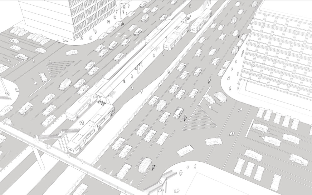
Existing Conditions
The introduction of a collective transport system, such as Bus Rapid Transit (BRT) or a light rail, may radically transform streets and intersections, with the only goal of increased efficiency of the transit service.
These corridors may continue for several blocks without intersections in order to avoid conflicts with crossing traffic. Pedestrians are channeled onto overhead bridges, and cyclists are forced to take long detours.
The illustration above depicts a main corridor designed to prioritize the through-movement of vehicles and mass transit. The central corridor does not intersect with local streets. Vehicles coming from the local street must turn right to proceed.
Cyclists ride in mixed traffic or on sidewalks, increasing the risk of conflict with motorists and pedestrians.
Large corner radii and wide lanes encourage speeding, and fences along the transit corridor prevent pedestrians from crossing it.
Crossing facilities are grade-separated and pedestrians are required to use elevated bridges to cross the street and to access the central boarding island for transit.

Bogota, Colombia
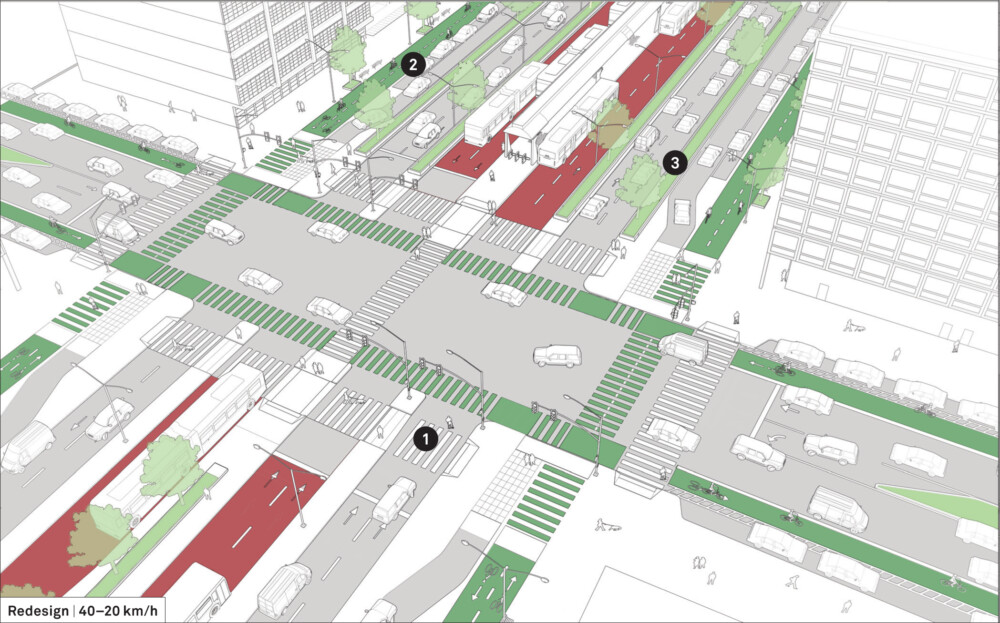
Design Guidance
The intersection is redesigned to increase permeability, prioritize pedestrians, and encourage non-motorized uses while maintaining an efficient transit system.
![]() Remove overhead bridges and replace them with at-grade crossings at intersections and mid-block locations, allowing pedestrians to directly access the transit stops at grade.
Remove overhead bridges and replace them with at-grade crossings at intersections and mid-block locations, allowing pedestrians to directly access the transit stops at grade.
Provide curb extensions and refuge islands to shorten crossing distances.
![]() Introduce parking-protected cycle tracks and buffered cycle lanes to provide a safer environment for cyclists.
Introduce parking-protected cycle tracks and buffered cycle lanes to provide a safer environment for cyclists.
Bidirectional cycle facilities on each side of this wide street reduce the need to cross the transitway and provide a high-quality corridor for the entire cycle network. Extend ground markings for cycle lanes through the conflict zone of the intersection, matching the width and positioning of the leading cycle lanes.
Remove fences in the median and replace them with planters and rows of trees on each side of the transit way.
![]() Separate local traffic and through-traffic. Remove curbside parking from the main roadway; instead provide it in the service lane where the speed is limited at 20 km/h.
Separate local traffic and through-traffic. Remove curbside parking from the main roadway; instead provide it in the service lane where the speed is limited at 20 km/h.
Recess parking from the intersection. Raise crossings and provide distinct treatments for the service lane to slow speeds and increase visibility between vehicles, cyclists, and pedestrians.
Manage or restrict turns across oncoming traffic to improve reliability of the transitway and overall safety. See: Operational and Management Strategies.

Yinchuan, China
Adapted by Global Street Design Guide published by Island Press.