-
About Streets
- Introduction
- Defining Streets
-
Shaping Streets
- The Process of Shaping Streets
- Aligning with City and Regional Agendas
- Involving the Right Stakeholders
- Setting a Project Vision
- Communication and Engagement
- Costs and Budgets
- Phasing and Interim Strategies
- Coordination and Project Management
- Implementation and Materials
- Management
- Maintenance
- Institutionalizing Change
- Measuring and Evaluating Streets
-
Street Design Guidance
- Designing Streets for Great Cities
- Designing Streets for Place
-
Designing Streets for People
- Utilities and Infrastructure
- Operational and Management Strategies
- Design Controls
-
Street Transformations
- Streets
-
Intersections
- Intersection Design Strategies
- Intersection Analysis
- Intersection Redesign
- Mini Roundabout
- Small Raised Intersection
- Neighborhood Gateway Intersection
- Intersection of Two-Way and One-Way Streets
- Major Intersection: Reclaiming the Corners
- Major Intersection: Squaring the Circle
- Major Intersection: Cycle Protection
- Complex Intersection: Adding Public Plazas
- Complex Intersection: Improving Traffic Circles
- Complex Intersection: Increasing Permeability
- Resources
Global Street Design Guide
-
About Streets
- Introduction
- Defining Streets
-
Shaping Streets
Back Shaping Streets
- The Process of Shaping Streets
- Aligning with City and Regional Agendas
- Involving the Right Stakeholders
- Setting a Project Vision
- Communication and Engagement
- Costs and Budgets
- Phasing and Interim Strategies
- Coordination and Project Management
- Implementation and Materials
- Management
- Maintenance
- Institutionalizing Change
-
Measuring and Evaluating Streets
Back Measuring and Evaluating Streets
-
Street Design Guidance
-
Designing Streets for Great Cities
Back Designing Streets for Great Cities
-
Designing Streets for Place
Back Designing Streets for Place
-
Designing Streets for People
Back Designing Streets for People
- Comparing Street Users
- A Variety of Street Users
-
Designing for Pedestrians
Back Designing for Pedestrians
- Designing for Cyclists
-
Designing for Transit Riders
Back Designing for Transit Riders
- Overview
- Transit Networks
- Transit Toolbox
-
Transit Facilities
Back Transit Facilities
-
Transit Stops
Back Transit Stops
-
Additional Guidance
Back Additional Guidance
-
Designing for Motorists
Back Designing for Motorists
-
Designing for Freight and Service Operators
Back Designing for Freight and Service Operators
-
Designing for People Doing Business
Back Designing for People Doing Business
-
Utilities and Infrastructure
Back Utilities and Infrastructure
- Utilities
-
Green Infrastructure and Stormwater Management
Back Green Infrastructure and Stormwater Management
-
Lighting and Technology
Back Lighting and Technology
-
Operational and Management Strategies
Back Operational and Management Strategies
- Design Controls
-
Street Transformations
-
Streets
Back Streets
- Street Design Strategies
- Street Typologies
-
Pedestrian-Priority Spaces
Back Pedestrian-Priority Spaces
-
Pedestrian-Only Streets
Back Pedestrian-Only Streets
-
Laneways and Alleys
Back Laneways and Alleys
- Parklets
-
Pedestrian Plazas
Back Pedestrian Plazas
-
Pedestrian-Only Streets
-
Shared Streets
Back Shared Streets
-
Commercial Shared Streets
Back Commercial Shared Streets
-
Residential Shared Streets
Back Residential Shared Streets
-
Commercial Shared Streets
-
Neighborhood Streets
Back Neighborhood Streets
-
Residential Streets
Back Residential Streets
-
Neighborhood Main Streets
Back Neighborhood Main Streets
-
Residential Streets
-
Avenues and Boulevards
Back Avenues and Boulevards
-
Central One-Way Streets
Back Central One-Way Streets
-
Central Two-Way Streets
Back Central Two-Way Streets
- Transit Streets
-
Large Streets with Transit
Back Large Streets with Transit
- Grand Streets
-
Central One-Way Streets
-
Special Conditions
Back Special Conditions
-
Elevated Structure Improvement
Back Elevated Structure Improvement
-
Elevated Structure Removal
Back Elevated Structure Removal
-
Streets to Streams
Back Streets to Streams
-
Temporary Street Closures
Back Temporary Street Closures
-
Post-Industrial Revitalization
Back Post-Industrial Revitalization
-
Waterfront and Parkside Streets
Back Waterfront and Parkside Streets
-
Historic Streets
Back Historic Streets
-
Elevated Structure Improvement
-
Streets in Informal Areas
Back Streets in Informal Areas
-
Intersections
Back Intersections
- Intersection Design Strategies
- Intersection Analysis
- Intersection Redesign
- Mini Roundabout
- Small Raised Intersection
- Neighborhood Gateway Intersection
- Intersection of Two-Way and One-Way Streets
- Major Intersection: Reclaiming the Corners
- Major Intersection: Squaring the Circle
- Major Intersection: Cycle Protection
- Complex Intersection: Adding Public Plazas
- Complex Intersection: Improving Traffic Circles
- Complex Intersection: Increasing Permeability
- Resources
- Guides & Publications
- Global Street Design Guide
- Designing Streets for People
- Designing for Transit Riders
- Transit Networks
Transit Networks
Transit network planning directly influences street design. Major routes with frequent service demand higher priority in street space allocation. Collective transport can provide convenient and reliable service given thoughtful geographic consideration and priority within the streets.
Geographic coverage of a transit network is relevant to both equity and efficiency. Transit networks are inherently linked to comprehensive planning that shapes land use and density decisions, and should be carefully coordinated. Transit systems can strategically attract new development and offer economic benefits to local businesses.
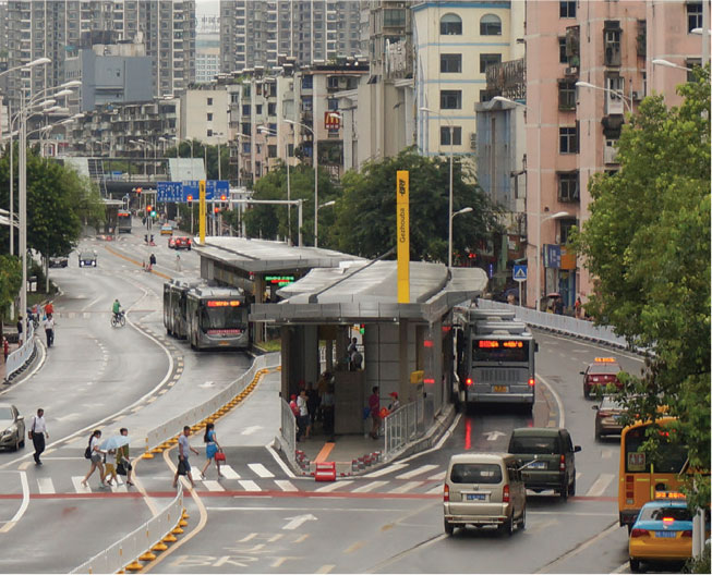
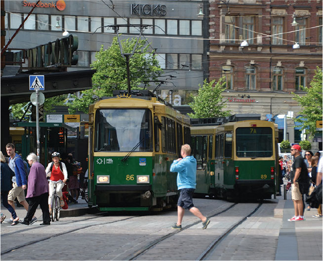
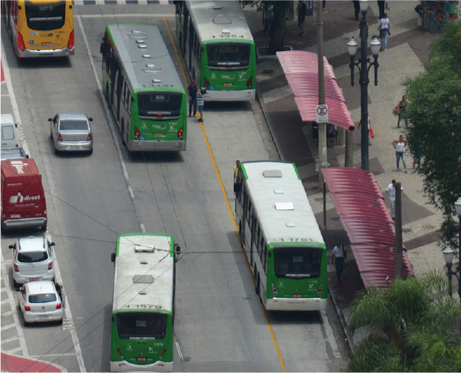
Prioritizing collective transport with dedicated on-street facilities helps a city move large numbers of people quickly and efficiently. This allows dedicating space within the street for other uses and supports sustainability goals.
Quality pedestrian environments around stops and stations, and easy access to cycle infrastructure such as cycle share, cycle lanes, and secure cycle parking spaces are critical to the success of a comprehensive mobility system.
Multiple collective transit systems can work together on urban streets to create a comprehensive and reliable network. Consider the following variables when designing or improving transit networks through street design.
Network Type
Network type is a contextual consideration in street design. The planned or existing network affects the efficiency of a mass transit system. Grid networks on major streets connecting to large employment activity hubs are the most competitive form in most cities allowing transfers between lines and access to the whole city.
Service Type
Service frequency, capacity, stop spacing, and destination density are major influences on street design. High-capacity services can offer greater speed, increased trip distance, and reliability, while local routes bridge shorter gaps, but with lower speeds and capacity. Effective networks employ a mix of service types based on contextual considerations and demands.
Network Directness and Legibility
Identify key travel and commuting corridors to help plan direct and frequent service and serve locations where less formalized transit bridges first- and last-mile gaps. The transit system must accommodate both the regular user and the first-time rider, providing predictable, reliable, and legible service.
Station Planning
Create dense and mixed-use developments around transit stops to increase transit ridership. Provide a high-quality public realm, walkable streets, comfortable station design, and interchange between complementary modes to further attract ridership, and compound transit benefits. Small collective transport generally offers a flexible operation when stops are not necessarily established or formalized. Planning stops for these type of services can be beneficial for both mass transit and small collective transport.
Network Integration
Integrated transit services extend network connectivity and increase the area covered by transit, encouraging modal shifts. Design quality transfer points to facilitate the safe integration between different types of transit services, such as rapid mass transit and local collective transport.
Performance
Measure transit network performance based on the user ability to conveniently reach destinations and the cost to do so. Fixed routes at predictable intervals with broad coverage areas and frequent services perform well for passengers. A single metric, such as the average travel time in a system, is not sufficient. Create system-wide measures such as the number of jobs an average resident can reach in 30, 45 or 60 minutes. See: Measuring and Evaluating Streets.
MAPPING COLLECTIVE TRANSPORT NAIROBI,
KENYA
Nearly one-third of citizens in Nairobi, Kenya use the city’s Matatu system of privately owned minibuses, but it was only recently officially mapped. A collaborative project of the University of Nairobi, Columbia University’s Center for Sustainable Urban Development, MIT’s Civic Data Design Lab, and Groupshot, Digital Matatus has been using crowd-sourcing data collection through mobile phones to standardize transit data for Nairobi’s Matatus, making the maps available to the public for the first time.

Transit Networks: Great transit networks provide a hierarchy of services that facilitate trips both long and short, crosstown and local. Concentrate investments on congested and high-volume corridors, while ensuring that geographic coverage serves all communities equitably. Plan transit networks for legibility, with an understanding of how riders use the system. Collective transport mode is less important than service frequency and destination access.

Adapted by Global Street Design Guide published by Island Press.
Next Section —