-
About Streets
- Introduction
- Defining Streets
-
Shaping Streets
- The Process of Shaping Streets
- Aligning with City and Regional Agendas
- Involving the Right Stakeholders
- Setting a Project Vision
- Communication and Engagement
- Costs and Budgets
- Phasing and Interim Strategies
- Coordination and Project Management
- Implementation and Materials
- Management
- Maintenance
- Institutionalizing Change
- Measuring and Evaluating Streets
-
Street Design Guidance
- Designing Streets for Great Cities
- Designing Streets for Place
-
Designing Streets for People
- Utilities and Infrastructure
- Operational and Management Strategies
- Design Controls
-
Street Transformations
- Streets
-
Intersections
- Intersection Design Strategies
- Intersection Analysis
- Intersection Redesign
- Mini Roundabout
- Small Raised Intersection
- Neighborhood Gateway Intersection
- Intersection of Two-Way and One-Way Streets
- Major Intersection: Reclaiming the Corners
- Major Intersection: Squaring the Circle
- Major Intersection: Cycle Protection
- Complex Intersection: Adding Public Plazas
- Complex Intersection: Improving Traffic Circles
- Complex Intersection: Increasing Permeability
- Resources
Global Street Design Guide
-
About Streets
- Introduction
- Defining Streets
-
Shaping Streets
Back Shaping Streets
- The Process of Shaping Streets
- Aligning with City and Regional Agendas
- Involving the Right Stakeholders
- Setting a Project Vision
- Communication and Engagement
- Costs and Budgets
- Phasing and Interim Strategies
- Coordination and Project Management
- Implementation and Materials
- Management
- Maintenance
- Institutionalizing Change
-
Measuring and Evaluating Streets
Back Measuring and Evaluating Streets
-
Street Design Guidance
-
Designing Streets for Great Cities
Back Designing Streets for Great Cities
-
Designing Streets for Place
Back Designing Streets for Place
-
Designing Streets for People
Back Designing Streets for People
- Comparing Street Users
- A Variety of Street Users
-
Designing for Pedestrians
Back Designing for Pedestrians
- Designing for Cyclists
-
Designing for Transit Riders
Back Designing for Transit Riders
- Overview
- Transit Networks
- Transit Toolbox
-
Transit Facilities
Back Transit Facilities
-
Transit Stops
Back Transit Stops
-
Additional Guidance
Back Additional Guidance
-
Designing for Motorists
Back Designing for Motorists
-
Designing for Freight and Service Operators
Back Designing for Freight and Service Operators
-
Designing for People Doing Business
Back Designing for People Doing Business
-
Utilities and Infrastructure
Back Utilities and Infrastructure
- Utilities
-
Green Infrastructure and Stormwater Management
Back Green Infrastructure and Stormwater Management
-
Lighting and Technology
Back Lighting and Technology
-
Operational and Management Strategies
Back Operational and Management Strategies
- Design Controls
-
Street Transformations
-
Streets
Back Streets
- Street Design Strategies
- Street Typologies
-
Pedestrian-Priority Spaces
Back Pedestrian-Priority Spaces
-
Pedestrian-Only Streets
Back Pedestrian-Only Streets
-
Laneways and Alleys
Back Laneways and Alleys
- Parklets
-
Pedestrian Plazas
Back Pedestrian Plazas
-
Pedestrian-Only Streets
-
Shared Streets
Back Shared Streets
-
Commercial Shared Streets
Back Commercial Shared Streets
-
Residential Shared Streets
Back Residential Shared Streets
-
Commercial Shared Streets
-
Neighborhood Streets
Back Neighborhood Streets
-
Residential Streets
Back Residential Streets
-
Neighborhood Main Streets
Back Neighborhood Main Streets
-
Residential Streets
-
Avenues and Boulevards
Back Avenues and Boulevards
-
Central One-Way Streets
Back Central One-Way Streets
-
Central Two-Way Streets
Back Central Two-Way Streets
- Transit Streets
-
Large Streets with Transit
Back Large Streets with Transit
- Grand Streets
-
Central One-Way Streets
-
Special Conditions
Back Special Conditions
-
Elevated Structure Improvement
Back Elevated Structure Improvement
-
Elevated Structure Removal
Back Elevated Structure Removal
-
Streets to Streams
Back Streets to Streams
-
Temporary Street Closures
Back Temporary Street Closures
-
Post-Industrial Revitalization
Back Post-Industrial Revitalization
-
Waterfront and Parkside Streets
Back Waterfront and Parkside Streets
-
Historic Streets
Back Historic Streets
-
Elevated Structure Improvement
-
Streets in Informal Areas
Back Streets in Informal Areas
-
Intersections
Back Intersections
- Intersection Design Strategies
- Intersection Analysis
- Intersection Redesign
- Mini Roundabout
- Small Raised Intersection
- Neighborhood Gateway Intersection
- Intersection of Two-Way and One-Way Streets
- Major Intersection: Reclaiming the Corners
- Major Intersection: Squaring the Circle
- Major Intersection: Cycle Protection
- Complex Intersection: Adding Public Plazas
- Complex Intersection: Improving Traffic Circles
- Complex Intersection: Increasing Permeability
- Resources
- Guides & Publications
- Global Street Design Guide
- Streets
- Neighborhood Streets
- Neighborhood Main Streets
- Example 3: 30 m
Example 3: 30 m
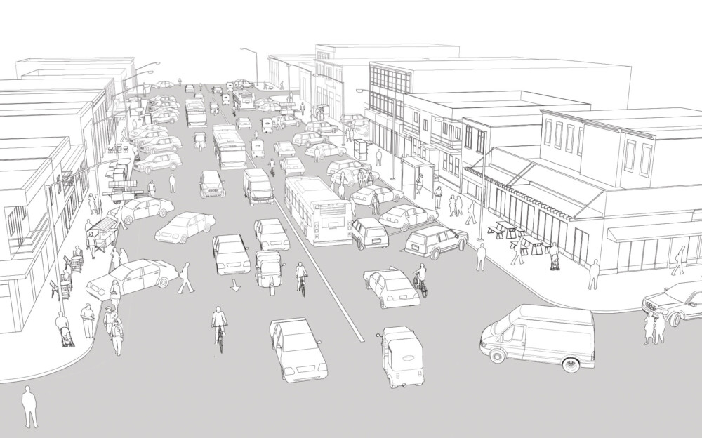
Existing Conditions
The illustration depicts a neighborhood main street with a very wide roadbed and unregulated parking on both sides. This street connects the outskirts with the city center, serving primarily as a vehicular thoroughfare.
Angled parking increases the turning radius at the intersection, encouraging fast turns and reducing visibility. Pedestrian crossings are not marked or signalized.
Motorists often fail to yield to pedestrian crossings. These conditions expose vulnerable users to conflicts.
Cars moving in and out of parking spaces block travel lanes and create dangerous conditions for cyclists. This is also a common cause of rear-end collisions.
Transit riders are forced to disembark into the road because parked cars block the bus from accessing the bus stop.
Sidewalks are inaccessible and often blocked or interrupted by parked cars, utility poles, street vendors, and other furnishings.
Some ground floor uses, such as loading, spill out onto the sidewalk, obstructing the clear path.

Addis Ababa, Ethiopia

Charleston, USA
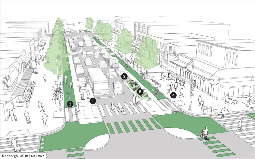
Design Guidance
Redesign the street to better serve the needs of all users. Protected cycle tracks, curb extensions, transit stops, and widened sidewalks distribute the space more equitably to encourage walking, cycling, and transit use.
Reduce the roadbed to one travel lane in each direction and convert angled parking into parallel parking.
![]() Allow transit vehicles to share the travel lanes with cars and provide island stops for fast, accessible boarding.
Allow transit vehicles to share the travel lanes with cars and provide island stops for fast, accessible boarding.
![]() Mark protected cycle tracks at conflict zones such as mid-block crossings, curb cuts, and through intersections.
Mark protected cycle tracks at conflict zones such as mid-block crossings, curb cuts, and through intersections.
![]() Alternate parking spaces with other services and uses such as refuge islands, sheltered transit stops, cycle-share stations, rain gardens, and wider loading bays for trucks.
Alternate parking spaces with other services and uses such as refuge islands, sheltered transit stops, cycle-share stations, rain gardens, and wider loading bays for trucks.
Add a raised, mid-block crossing to increase permeability and support a safer pedestrian environment.
![]() Widen sidewalks to allow multiple activities to take place on the street without obstructing the clear path. Plant trees, install street furniture, and create an improved public realm that supports local businesses.
Widen sidewalks to allow multiple activities to take place on the street without obstructing the clear path. Plant trees, install street furniture, and create an improved public realm that supports local businesses.
Install ramps and tactile strips to make sidewalks and crossings accessible.
![]() Adopt green infrastructure strategies, including rain gardens and permeable paving, to improve water management and reduce water stagnation in low-lying areas. See: Green Infrastructure.
Adopt green infrastructure strategies, including rain gardens and permeable paving, to improve water management and reduce water stagnation in low-lying areas. See: Green Infrastructure.

Copenhagen, Denmark
Adapted by Global Street Design Guide published by Island Press.
Next Section —