-
About Streets
- Introduction
- Defining Streets
-
Shaping Streets
- The Process of Shaping Streets
- Aligning with City and Regional Agendas
- Involving the Right Stakeholders
- Setting a Project Vision
- Communication and Engagement
- Costs and Budgets
- Phasing and Interim Strategies
- Coordination and Project Management
- Implementation and Materials
- Management
- Maintenance
- Institutionalizing Change
- Measuring and Evaluating Streets
-
Street Design Guidance
- Designing Streets for Great Cities
- Designing Streets for Place
-
Designing Streets for People
- Utilities and Infrastructure
- Operational and Management Strategies
- Design Controls
-
Street Transformations
- Streets
-
Intersections
- Intersection Design Strategies
- Intersection Analysis
- Intersection Redesign
- Mini Roundabout
- Small Raised Intersection
- Neighborhood Gateway Intersection
- Intersection of Two-Way and One-Way Streets
- Major Intersection: Reclaiming the Corners
- Major Intersection: Squaring the Circle
- Major Intersection: Cycle Protection
- Complex Intersection: Adding Public Plazas
- Complex Intersection: Improving Traffic Circles
- Complex Intersection: Increasing Permeability
- Resources
Global Street Design Guide
-
About Streets
- Introduction
- Defining Streets
-
Shaping Streets
Back Shaping Streets
- The Process of Shaping Streets
- Aligning with City and Regional Agendas
- Involving the Right Stakeholders
- Setting a Project Vision
- Communication and Engagement
- Costs and Budgets
- Phasing and Interim Strategies
- Coordination and Project Management
- Implementation and Materials
- Management
- Maintenance
- Institutionalizing Change
-
Measuring and Evaluating Streets
Back Measuring and Evaluating Streets
-
Street Design Guidance
-
Designing Streets for Great Cities
Back Designing Streets for Great Cities
-
Designing Streets for Place
Back Designing Streets for Place
-
Designing Streets for People
Back Designing Streets for People
- Comparing Street Users
- A Variety of Street Users
-
Designing for Pedestrians
Back Designing for Pedestrians
- Designing for Cyclists
-
Designing for Transit Riders
Back Designing for Transit Riders
- Overview
- Transit Networks
- Transit Toolbox
-
Transit Facilities
Back Transit Facilities
-
Transit Stops
Back Transit Stops
-
Additional Guidance
Back Additional Guidance
-
Designing for Motorists
Back Designing for Motorists
-
Designing for Freight and Service Operators
Back Designing for Freight and Service Operators
-
Designing for People Doing Business
Back Designing for People Doing Business
-
Utilities and Infrastructure
Back Utilities and Infrastructure
- Utilities
-
Green Infrastructure and Stormwater Management
Back Green Infrastructure and Stormwater Management
-
Lighting and Technology
Back Lighting and Technology
-
Operational and Management Strategies
Back Operational and Management Strategies
- Design Controls
-
Street Transformations
-
Streets
Back Streets
- Street Design Strategies
- Street Typologies
-
Pedestrian-Priority Spaces
Back Pedestrian-Priority Spaces
-
Pedestrian-Only Streets
Back Pedestrian-Only Streets
-
Laneways and Alleys
Back Laneways and Alleys
- Parklets
-
Pedestrian Plazas
Back Pedestrian Plazas
-
Pedestrian-Only Streets
-
Shared Streets
Back Shared Streets
-
Commercial Shared Streets
Back Commercial Shared Streets
-
Residential Shared Streets
Back Residential Shared Streets
-
Commercial Shared Streets
-
Neighborhood Streets
Back Neighborhood Streets
-
Residential Streets
Back Residential Streets
-
Neighborhood Main Streets
Back Neighborhood Main Streets
-
Residential Streets
-
Avenues and Boulevards
Back Avenues and Boulevards
-
Central One-Way Streets
Back Central One-Way Streets
-
Central Two-Way Streets
Back Central Two-Way Streets
- Transit Streets
-
Large Streets with Transit
Back Large Streets with Transit
- Grand Streets
-
Central One-Way Streets
-
Special Conditions
Back Special Conditions
-
Elevated Structure Improvement
Back Elevated Structure Improvement
-
Elevated Structure Removal
Back Elevated Structure Removal
-
Streets to Streams
Back Streets to Streams
-
Temporary Street Closures
Back Temporary Street Closures
-
Post-Industrial Revitalization
Back Post-Industrial Revitalization
-
Waterfront and Parkside Streets
Back Waterfront and Parkside Streets
-
Historic Streets
Back Historic Streets
-
Elevated Structure Improvement
-
Streets in Informal Areas
Back Streets in Informal Areas
-
Intersections
Back Intersections
- Intersection Design Strategies
- Intersection Analysis
- Intersection Redesign
- Mini Roundabout
- Small Raised Intersection
- Neighborhood Gateway Intersection
- Intersection of Two-Way and One-Way Streets
- Major Intersection: Reclaiming the Corners
- Major Intersection: Squaring the Circle
- Major Intersection: Cycle Protection
- Complex Intersection: Adding Public Plazas
- Complex Intersection: Improving Traffic Circles
- Complex Intersection: Increasing Permeability
- Resources
- Guides & Publications
- Global Street Design Guide
- Intersections
- Major Intersection: Reclaiming the Corners
Major Intersection: Reclaiming the Corners
The intersection of two major streets can act as both a barrier and a node. Redesigning major intersections requires a critical evaluation of the tools and trade-offs available to make an intersection work better for everyone.
Weigh intersection geometry, signal timing, and traffic volumes to formulate a design that clarifies the hierarchy of street users, while enhancing the safety and legibility of the intersection.


Existing Conditions
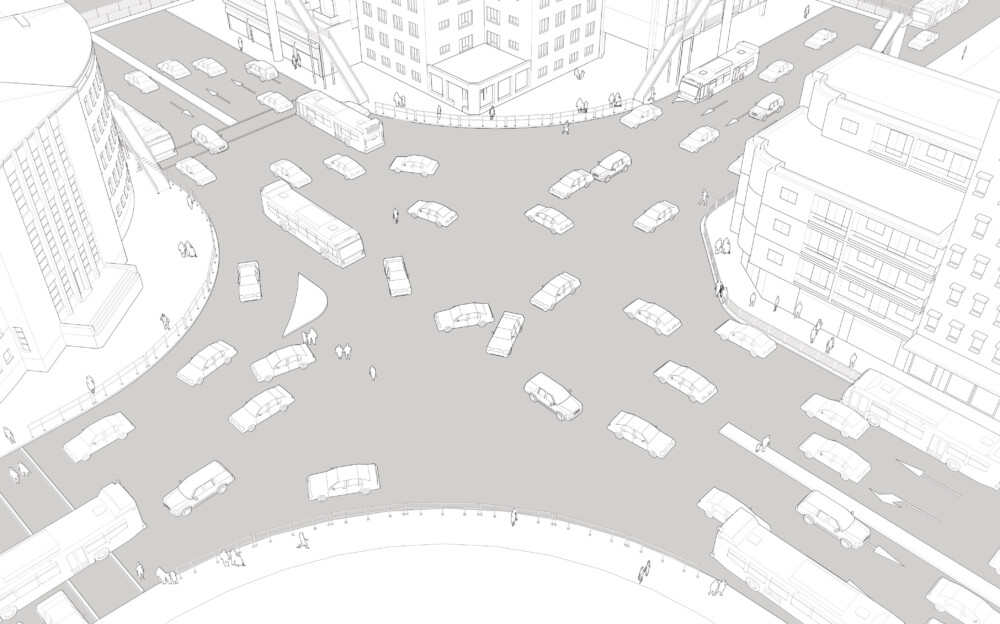
In this illustration, a large, one-way street with four travel lanes intersects with a two-way street carrying three lanes in each direction. This intersection is extremely wide and chaotic, with an unbalanced allocation of space between modes. It has long traffic signal cycles.
Designed primarily for motorists, the sidewalks are too narrow or non-existent.
Crossing facilities are grade-separated by overhead foot bridges that significantly increase the travel time for pedestrians and are inaccessible to those facing ambulatory difficulties. Fences along the sidewalk, installed to prevent people from walking on the roadbed and to impede illegal parking, further increase walking distances. These are often utilized by vendors to display goods.
Large corner radii designed to accommodate high-speed turns and inadequate pedestrian refuge islands present a danger to vulnerable users. Slip lanes at the corners encourage high speeds for motorists turning without having to pause.
Design Guidance
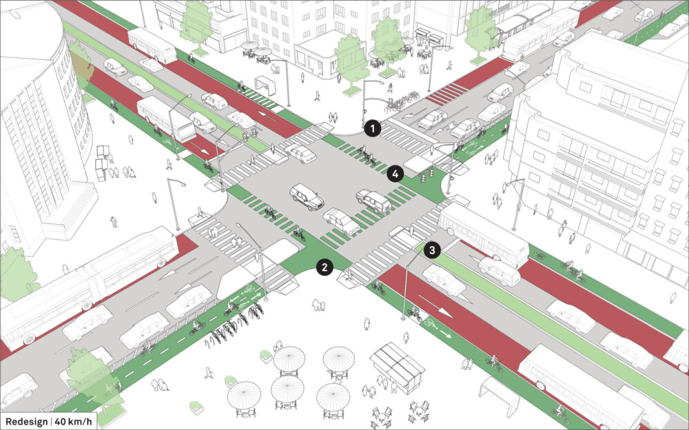
This reconstruction shows the conversion of a large car-oriented intersection into a compact, well-delineated, and safer node.
![]() Remove pedestrian overpasses and replace them with at-grade crossings. This reduces crossing time and distance, increases sidewalk space, and makes the pedestrian crossing accessible for all users.
Remove pedestrian overpasses and replace them with at-grade crossings. This reduces crossing time and distance, increases sidewalk space, and makes the pedestrian crossing accessible for all users.
![]() Reduce turning radii and reclaim space at the corners to safely accommodate high pedestrian volumes. This creates additional space for transit stops and street vendors.
Reduce turning radii and reclaim space at the corners to safely accommodate high pedestrian volumes. This creates additional space for transit stops and street vendors.
Install pedestrian refuge islands to reduce crossing distance and provide a protected waiting space.
![]() Reduce the lane width and extend the central median as a simple, cost-effective measure to improve safety.
Reduce the lane width and extend the central median as a simple, cost-effective measure to improve safety.
![]() Extend ground markings for cycle lanes through the conflict zone of the intersection, matching the width and positioning of the leading cycle lanes.
Extend ground markings for cycle lanes through the conflict zone of the intersection, matching the width and positioning of the leading cycle lanes.
Prioritize mass transit to increase the capacity on busy streets. Convert a travel lane in each direction of the two-way street, and one lane of the one-way street, into transit-only lane.
On the one-way street, remove one travel lane to add a parking-protected, two-way cycle track.
On the two-way street, add a raised cycle track on each side of the street, ramping lanes up to meet sidewalk level when they are adjacent to transit stops. Ensure a change in markings to indicate these potential areas of conflict between cyclists and transit riders.
Define travel lanes through markings and reduce their width in order to reduce vehicular speed.


Addis Ababa, Ethiopia. An interim transformation showcasing the principles such as tightening the corner radii, adding appropriate intersection markings and reducing crossing distances.
Adapted by Global Street Design Guide published by Island Press.
Next Section —