-
About Streets
- Introduction
- Defining Streets
-
Shaping Streets
- The Process of Shaping Streets
- Aligning with City and Regional Agendas
- Involving the Right Stakeholders
- Setting a Project Vision
- Communication and Engagement
- Costs and Budgets
- Phasing and Interim Strategies
- Coordination and Project Management
- Implementation and Materials
- Management
- Maintenance
- Institutionalizing Change
- Measuring and Evaluating Streets
-
Street Design Guidance
- Designing Streets for Great Cities
- Designing Streets for Place
-
Designing Streets for People
- Utilities and Infrastructure
- Operational and Management Strategies
- Design Controls
-
Street Transformations
- Streets
-
Intersections
- Intersection Design Strategies
- Intersection Analysis
- Intersection Redesign
- Mini Roundabout
- Small Raised Intersection
- Neighborhood Gateway Intersection
- Intersection of Two-Way and One-Way Streets
- Major Intersection: Reclaiming the Corners
- Major Intersection: Squaring the Circle
- Major Intersection: Cycle Protection
- Complex Intersection: Adding Public Plazas
- Complex Intersection: Improving Traffic Circles
- Complex Intersection: Increasing Permeability
- Resources
Global Street Design Guide
-
About Streets
- Introduction
- Defining Streets
-
Shaping Streets
Back Shaping Streets
- The Process of Shaping Streets
- Aligning with City and Regional Agendas
- Involving the Right Stakeholders
- Setting a Project Vision
- Communication and Engagement
- Costs and Budgets
- Phasing and Interim Strategies
- Coordination and Project Management
- Implementation and Materials
- Management
- Maintenance
- Institutionalizing Change
-
Measuring and Evaluating Streets
Back Measuring and Evaluating Streets
-
Street Design Guidance
-
Designing Streets for Great Cities
Back Designing Streets for Great Cities
-
Designing Streets for Place
Back Designing Streets for Place
-
Designing Streets for People
Back Designing Streets for People
- Comparing Street Users
- A Variety of Street Users
-
Designing for Pedestrians
Back Designing for Pedestrians
- Designing for Cyclists
-
Designing for Transit Riders
Back Designing for Transit Riders
- Overview
- Transit Networks
- Transit Toolbox
-
Transit Facilities
Back Transit Facilities
-
Transit Stops
Back Transit Stops
-
Additional Guidance
Back Additional Guidance
-
Designing for Motorists
Back Designing for Motorists
-
Designing for Freight and Service Operators
Back Designing for Freight and Service Operators
-
Designing for People Doing Business
Back Designing for People Doing Business
-
Utilities and Infrastructure
Back Utilities and Infrastructure
- Utilities
-
Green Infrastructure and Stormwater Management
Back Green Infrastructure and Stormwater Management
-
Lighting and Technology
Back Lighting and Technology
-
Operational and Management Strategies
Back Operational and Management Strategies
- Design Controls
-
Street Transformations
-
Streets
Back Streets
- Street Design Strategies
- Street Typologies
-
Pedestrian-Priority Spaces
Back Pedestrian-Priority Spaces
-
Pedestrian-Only Streets
Back Pedestrian-Only Streets
-
Laneways and Alleys
Back Laneways and Alleys
- Parklets
-
Pedestrian Plazas
Back Pedestrian Plazas
-
Pedestrian-Only Streets
-
Shared Streets
Back Shared Streets
-
Commercial Shared Streets
Back Commercial Shared Streets
-
Residential Shared Streets
Back Residential Shared Streets
-
Commercial Shared Streets
-
Neighborhood Streets
Back Neighborhood Streets
-
Residential Streets
Back Residential Streets
-
Neighborhood Main Streets
Back Neighborhood Main Streets
-
Residential Streets
-
Avenues and Boulevards
Back Avenues and Boulevards
-
Central One-Way Streets
Back Central One-Way Streets
-
Central Two-Way Streets
Back Central Two-Way Streets
- Transit Streets
-
Large Streets with Transit
Back Large Streets with Transit
- Grand Streets
-
Central One-Way Streets
-
Special Conditions
Back Special Conditions
-
Elevated Structure Improvement
Back Elevated Structure Improvement
-
Elevated Structure Removal
Back Elevated Structure Removal
-
Streets to Streams
Back Streets to Streams
-
Temporary Street Closures
Back Temporary Street Closures
-
Post-Industrial Revitalization
Back Post-Industrial Revitalization
-
Waterfront and Parkside Streets
Back Waterfront and Parkside Streets
-
Historic Streets
Back Historic Streets
-
Elevated Structure Improvement
-
Streets in Informal Areas
Back Streets in Informal Areas
-
Intersections
Back Intersections
- Intersection Design Strategies
- Intersection Analysis
- Intersection Redesign
- Mini Roundabout
- Small Raised Intersection
- Neighborhood Gateway Intersection
- Intersection of Two-Way and One-Way Streets
- Major Intersection: Reclaiming the Corners
- Major Intersection: Squaring the Circle
- Major Intersection: Cycle Protection
- Complex Intersection: Adding Public Plazas
- Complex Intersection: Improving Traffic Circles
- Complex Intersection: Increasing Permeability
- Resources
- Guides & Publications
- Global Street Design Guide
- Streets
- Special Conditions
- Post-Industrial Revitalization
- Case Study: Jellicoe St.; Auckland, New Zealand
Case Study: Jellicoe St.; Auckland, New Zealand

Location: Wynyard Quarter, North Wharf, Auckland, New Zealand
Population: 1.4 million
Metro: 1.5 million
Length: 400 m
Area: 14,000 m²
Right-of-way: 23 m
Context: Before: Industrial. After: Mixed-Use.
Cost: 24 million NZD (15 million USD)
Funding: Public
Project Sponsors: Auckland Waterfront Development Agency
Max. Speed: 30 km/h
Overview
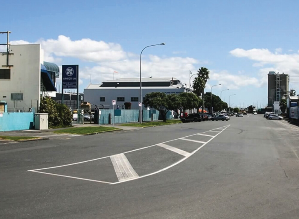
The transformation of Jellicoe Street is part of the larger revitalization project of the Wynyard Quarter, from an industrial port area to an active and livable waterfront neighborhood. The area is located on the edge of the city, close to the harbor, on contaminated land.
Public space has been designed to catalyze development and foster the conversion of old hangars and warehouses into a cultural and recreational strip.
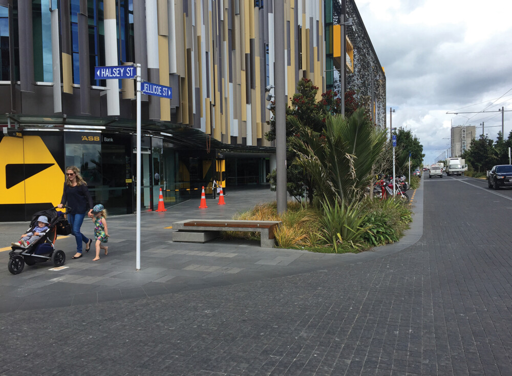
The street was transformed from an industrial service road to a lush pedestrian boulevard.
The innovative approach that integrated sustainability measures has become the new benchmark for citywide streetplanting strategies.


Key Elements
Rain garden network integrated into the street design.
Limited vehicle access.
Curbs removed (shared-space
approach).
Integration of light rail (tram).
Use of native and local plants.
Goals
- Create a unique destination and a civic space.
- Bring recreational activity to the site.
- Transform the area while preserving the industrial heritage.
- Achieve an environment that is well connected yet offers distinctly different experiences.
Lessons Learned
Although surface treatment reduced speeds, the driver behavior forced the Waterfront Development Agency to implement controls such as wheel stops adjacent to rain gardens and dotted yellow lines to restrict parking.
Usage of parking spaces was monitored and changes were made accordingly, including replacing parking with cycle parking or loading zones.
The following measures were used to create a more sustainable street environment:
- Water-sensitive design including capturing, treating, and reusing stormwater.
- Reuse of existing site materials such as concrete blocks from a nearby cement factory.
- Promotion of healthy activities, environmental education, and social interaction.
Evaluation


Project Timeline

Adapted by Global Street Design Guide published by Island Press.